
Tanzania Petroleum Development Corporation (TPDC) is the National Oil Company of Tanzania through which the Ministry of Energy and Minerals implements its petroleum exploration and development policies. TPDC has a manpower strength of about 400 and is organized into seven directorates and three Units, namely: Directorate of Upstream, Directorate of Downstream, Directorate of Finance, Directorate of Legal Services, Directorate of Cooperate Strategy and Planning, Directorate of Corporate Management, Directorate of Internal Audit, Communication Unit, Procurement Unit and Risk Management Unit.
Tanzania has been intermittently explored over the last 60 years. Most of the multinational petroleum companies were represented in the area, at one time or another. Significant gas discoveries were made at Songo Song, Mnazi Bay and in the southern deepsea basin opposite Ruvuma. More than 50 exploration wells and development wells have been drilled providing vital geological information of the subsurface and potential for hydrocarbons. The cumulative seismic coverage in public domain is approximately 100,000 km; 70,000 km offshore and 30,000 km onshore, including theinterior rift basins. About 15,000 square km of 3D seismic data has been acquired in the offshore areas.
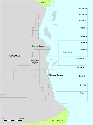
Songo Songo Gas Fields
The field is located on and offshore Songo Songo Island, about 15 km from the mainland and 200 km south of Dar es Salaam. The discovery well, Songo Songo-1, was drilled in l974 by AGIP. Songo Songo is a large N-S trending structure containing one to two TCF of gas reserves. The gas is contained in Lower Cretaceous inner shelf sand reservoirs with porosities averaging greater than 20%, and net porous intervals up to 155 m thick. The structure was uplifted during the Early Cretaceous and the reservoir modified by the Mid Cretaceous regional unconformity. The trap consists of two faulted highs separated by a saddle. A series of N-S and NW-SE trending faults step down to the east. This faulting, regional eastward tilting, and rapid Tertiary sedimentation created more growth faults which mostly sole out in the sealing shales of the Upper Cretaceous Ruaruke Formation. The Lower Cretaceous reservoirs are not affected by this later episode of faulting. Continued activity along these faults resulted in the development of broad, low relief anticlines. The gas appears to have been sourced from post mature organic material of Jurassic or Early Cretaceous age. The associated liquids are probably sourced from mature organic matter of Early Cretaceous and Middle Cretaceous age and seem to have migrated from a nearby basin.
Mnazi Bay
AGIP drilled the discovery well, Mnazi Bay-1, in l982. The well encountered commercial quantities of gas in two Oligocene sands within the Mnazi Bay Clay Formation. These sands have porosities of 15 to 25% and permeabilities up to 560 md. Drill stem tests produced flows of 3.5 x 10⁵ m 3 / day (12.5 MMCF/d). Based on one well and existing seismic coverage, the reserves at Mnazi Bay are estimated to be in the 1 TCF range. The gas is considered thermogenic but no source identification has been made.
Hydrocarbon Occurrence
Several oils shows have been earmarked. The known oil seeps of Tanzania are located at Tundaua on the west coast of Pemba Island, Wingayongo and at Msimbati near Mnazi Bay and in the Interior Rift Basins. The Pemba Island seep indicates a marine source, which has been correlated with Campanian-Maastrichtian shales. However, the typing of the seep does not correlate with oil shows from the nearby Pemba-5 well. It appears that two separate sources are involved. The Wingayongo oil seep at the northern flank of the Rufiji Trough shows unusual biomarker characteristics, which have been interpreted to be derived from a source rock deposited in a restricted carbonate, lacustrine environment. The Makarawe Shale (Bajocian) is a possible source of this seep. Seeps at Msimbati near the Mnazi Bay gas discovery indicate two families of oil; one is interpreted to be generated from a carbonate source rock deposited in a strongly reducing environment; the other contains significant terrestrial organic matter and biomarkers of Late Cretaceous or younger age. A number of oil seeps and slicks have been reported from the Interior Rift Basins. Oil seeps were reported from Lake Tanganyika, as early as 1896, and in more recent times, project PROBE found an oil film on the lake. Oil shows have been reported from the Pemba-5, Mandawa-7, Mafia-1, Mita Gama-1 wells. Cut fluorescence and staining from seven other wells and three boreholes have been observed. Songo Songo wells yielded small amounts of oil, which are low in sulfur with 33E - 47E API.
Source Rock Characteristics
Oil prone source rocks have been identified in the Lower to Middle Jurassic Pindiro or Nondwa carbonate/evaporites, as shown in the Mandawa-7, Mbuo-1, and Mita Gamma-1 wells. They contain a rich mixture of Type I and III kerogen, with TOCs greater than 9%. The Permo-Triassic and possibly even some early Jurassic sediments are dominated by Type III kerogen, although rocks with TOC of 7% and a HI of 386 mgHC/g TOC occur in the Lukuledi-1 well, in the Ruvuma Basin. The section above the Middle Jurassic is typically dominated by Type III kerogen and is essentially gas prone. The Upper Cretaceous in Kimbiji East-1 contains TOCs up to 12%. Cretaceous and Tertiary source potential has also been speculated. Eocene lignites and organic rich shales are present in wells around the Songo Songo Gas Field. Occurrences of oil in a Songo Songo well and in the Pemba-5 well have been described in the section on Hydrocarbon Occurrences. Basin studies, chemical analysis and burial history and maturation modeling indicate that extensive hydrocarbon generating 'kitchens' are likely to occur within the basins. Hydrocarbons generated in the Karoo basins may have accumulated in reservoirs of the same age, or migrated into Lower Cretaceous sands. The regional Upper Cretaceous shales of the Ruaruke hydrocarbons generated in the Lower Cretaceous shales in the distal (offshore) areas could be expected to migrate laterally and updip into the younger Cretaceous and Tertiary sequences. The Interior Basins contain Lacustrine Karoo sediments (4 to 5% TOC), with 30% Type I and II kerogen. The Tertiary Lake Bed Formation contains up to 4.9% TOC, consisting of Type I and II kerogen.
Deep Off Shore Basins
The Mafia Deep Offshore Basin (MDOB) of southern Tanzania is one of the several East African basins which resulted from the break-up of the Gondwana continent from the Middle Jurassic onwards. The basin occupies an area of some 75,000 km developed between the Tanzanian continental shelf edge and the Davie Fracture Zone 200 km east of the coast. The water depth ranges form approximately 500m to a maximum of 3300m in the southeast of the basin. The availability of a modern high resolution seismic data has allowed the geological development of the basin to be interpreted in far greater detail than previously. Prior to this study the geology of the basin had been interpreted only from very widely spaced reconnaissance seismic data of the Sea Gap Group proprietary survey (1976) and the Lamont-Doherty East Africa Margin study (Coffin & Rabinowitz, 1988). The MDOB offers some of the few remaining frontier exploration opportunities in Africa. It is situated adjacent to the petroliferous Tanzanian Coastal Basin, where there are known onshore oil seeps and subsurface gas discoveries. the extrapolation of well data from this coastal area in combination with the stratigraphic and structural interpretation of the MDOB has facilitated the definition of its petroleum potential. Following licencing of the areas and subsequent exploration drilling by Petrobas, BG and Statoil, sizeable gas discoveries have been made mainly in the cretaceous sections.
Website