The recent Australian acreage release focuses heavily on the northwest shelf. PGS seismic data and studies provide excellent coverage for basin-scale evaluation, prospect analysis, and production planning of the opportunities on offer. This includes outputs of a recent collaboration with ION.
The Australia offshore acreage release for 2020 offers blocks across all the major northwest shelf basin structures. Understanding the basin-scale geological framework and the various play types that exist within each of the major basins can help exploration teams optimize their evaluation resources and pinpoint specific settings that best suit their exploration criteria.
“PGS is uniquely placed to support exploration teams looking at Australia 2020 licensing opportunities, with the tools to support the work such as our comprehensive basin reviews and integrated seismic products across the entire Westralian Super-basin,” says Rick Irving PGS Country Manager for Australia.
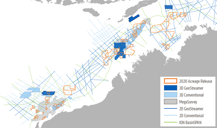
PGS MultiClient data for Australia 2020 offshore licensing opportunities, including ION 2D data
Westralia Access and WestraliaSPAN
A new collaboration between PGS and ION has added the WestraliaSPAN survey to the Westralia Access regional study, providing over 25 000 km of data that is engineered for basin-scale evaluation.
The regional study maps key horizons and ties wells across the entire shelf from the Northern Carnarvon basin through to the Bonaparte basin and provides commentary on the play types and key sequences expected in each basin.
Well data has been integral to the study, guiding the PSDM velocity model building and driving the reservoir characterization workflows. With a full suite of Prospect Scanner AVO volumes, gravity and magnetics report, and collaboration with local experts, this is one of the most comprehensive studies of the North West Shelf to date. Nearly all of the W20 blocks are covered directly by the PGS Westralia Access and ION WestraliaSPAN surveys.
Blocks W20-5 and W20-6 | Browse Basin MegaSurvey
Blocks W20-5 and W20-6 are situated over prospective Echuca Shoals, Vulcan, and Plover petroleum systems (Mesozoic age). The PGS Aurora MC3D survey provides good coverage over block W20-5.
The Aurora and Ichthys datasets were reprocessed in 2019, providing greatly enhanced imaging of the key horizons and fault systems. Improved results are provided by:
- GeoStreamer broadband signal processing
- Cascaded 3D demultiple techniques
- Full waveform inversion.
Including Caswell MC3D, this GeoStreamer PSDM volume covers over 18 500 sq. km and provides a reliable and valuable resource that is great for prospectivity screening and ideal for inversion and other prestack reservoir characterization workflows.
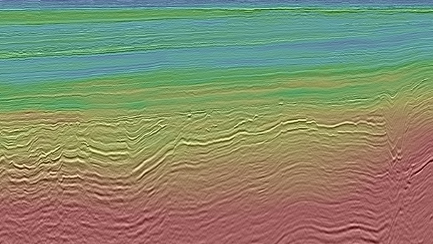
Aurora MC3D PSDM over W20-5
Block W20-6 is covered by part of the Browse MegaSurvey, nestled between the Aurora MC3D to the east, and the Caswell MC3D to the north. Reprocessing and integration with the GeoStreamer volumes are scheduled for 2021. We expect improved fault delineation at the Jurassic level and cleaner data with improved demultiple
Proven petroleum systems map well into this area with hydrocarbon expulsion modeling, suggesting that approximately 140 billion barrels have been expelled from the source rocks for the area. With existing accumulations within the basin accounting for less than 1% of this total, there is still very high potential for large future discoveries.
The Westralia Access and WestraliaSPAN data package is extremely valuable when a broader understanding of an area is needed, as it provides the ability to tap into the well data, velocity models, and key horizons at any point across the shelf.
Carnarvon Block W20-21 | Mawson 2019 PSDM
The release of block W20-21, located within the 2019 Mawson MC3D survey area coincides with the completion of the PSDM processing. Numerous Mungaroo Fm/Formation structural leads, which exist throughout the area, have been clearly imaged by the data.
A pinnacle reef complex encroaches on the W20-21 acreage and overlies numerous prospective closures. Great care was taken to ensure an accurate velocity model was produced to enhance the imaging beneath the pinnacle reef complex and provide confidence in the mapping of low relief structures.
This is a proven petroleum system with the Mungaroo formation providing the source, reservoir, and intra-formation seals. Trapping structures are commonly tilted fault blocks and associated drapes
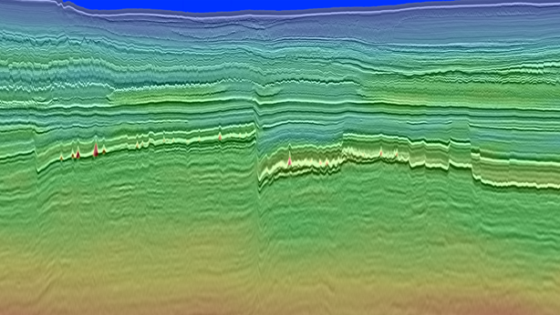
Mawson MC3D PSDM over W20-21
KeyFacts Energy Industry Directory: PGS