MapStand are now official Esri partners.
The new partnership with Esri is opening up new geospatial possibilities for the energy sector. By integrating MapStand’s global energy datasets with ArcGIS Online (AGOL), MapStand are bringing real-time, interactive energy intelligence to a single, seamless platform.
This collaboration allows clients to leverage advanced mapping, powerful spatial analysis, and enhanced visualisations—all within the Esri ecosystem.
Whether it’s renewable energy project development, oil & gas infrastructure, or decarbonisation initiatives, MapStand and Esri empower smarter decisions, streamlined workflows, and enhanced collaboration.
Key partnership outcomes include:
- Enhanced mapping & visualisation capabilities
- Powerful spatial analysis tools, from proximity checks to density mapping
- Seamless collaboration across teams and stakeholders
- Enterprise-level integration for secure, governed systems
- Automated updates to keep clients informed with real-time data
This partnership will enable energy professionals to map smarter, plan better, and contribute to a sustainable future.
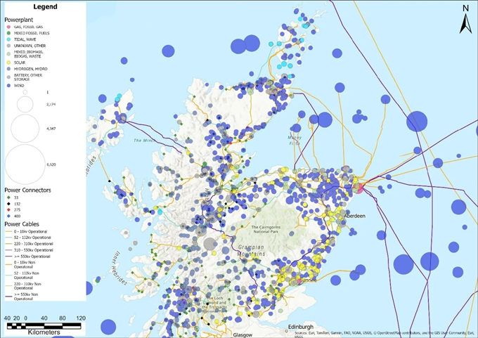
The map above offers a detailed overview of the energy infrastructure in the northern regions of Scotland, showcasing the distribution of power plants, power connectors, and power cables. The size of each power plant symbol represents its capacity, with varying energy sources including fossil fuels, wind, solar, and other renewables. Additionally, the map highlights the operational status and voltage levels of power connectors and cables, providing key insights into the region's energy landscape and its transition towards more sustainable and resilient energy solutions.
Struggling with siloed energy data or laborious manual workflows?
MapStand’s integration with ArcGIS Online tackles these challenges by delivering advanced geospatial energy intelligence in a single, seamless platform. By bringing its rich, global energy datasets into ArcGIS Online (AGOL), MapStand aligns with the world’s leading GIS platform—delivering added value to clients in oil & gas, renewables, research, and consulting. This collaboration offers both strategic and technical advantages, from advanced visualisation and analysis to broader reach and frictionless integration into existing GIS workflows.
Building on a Strong Geospatial Foundation
MapStand specializes in geospatial research for the global energy sector, offering up-to-date data on power generation, transmission networks, oil and gas infrastructure (upstream to downstream), and emerging decarbonisation technologies like hydrogen and CCUS. This data is made available via interactive maps, dashboards, and OGC (WMS/WFS) web services, which allow clients to stream content directly into their GIS systems without cumbersome data handling.
With many clients already using Esri tools to plan pipelines, site renewable projects, and assess assets, the ArcGIS Online partnership ensures MapStand’s data integrates effortlessly into existing workflows—extending accessibility through a platform clients know and trust.
New Capabilities with ArcGIS Online
1. Enhanced Mapping & Visualisation
ArcGIS Online brings MapStand data to life with smart symbology, high-resolution basemaps, and 3D visualisations. Users can explore global infrastructure layers, such as pipelines or wind farms, interactively in Map Viewer or Dashboards—combining realtime maps with key performance metrics.
2. Powerful Spatial Analysis
With AGOL, users can go beyond static maps. Built-in tools support analyses such as proximity checks (e.g. nearest grid connection), density mapping (e.g. clustering of solar farms), and terrain-based routing. These capabilities allow clients to unlock trends and insights without needing desktop software—AGOL’s cloud handles it all.
3. Seamless Collaboration
ArcGIS Online simplifies sharing. Clients can publish live maps and dashboards using MapStand data and share them internally, with stakeholders, or embed them in portals. Group access and permission control ensure secure collaboration, supporting everything from project planning to public engagement.
4. Enterprise Integration
Organizations using ArcGIS Enterprise can synchronize MapStand-hosted layers from AGOL into their private environments via Esri’s distributed collaboration tools. This enables internal teams to consume MapStand data within secure, governed systems—while ArcGIS Pro users can bring it directly into advanced workflows or offline analysis.
5. Performance & Scalability
Esri’s infrastructure offers speed and reliability. Whether viewing MapStand data at a national or global scale, ArcGIS Online delivers fast load times and smooth interaction, even for detailed datasets. Vector tiles, hosted feature layers, and optimized OGC formats ensure performance at scale.
6. Automated Updates
Through automation tools and scripts, MapStand can push regular updates to ArcGIS Online layers. Clients benefit from realtime data refreshes, always working with the most current infrastructure insights—whether for new projects, updates, or market changes.
KeyFacts Energy Industry Directory: MapStand