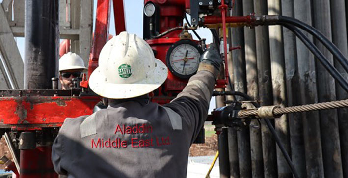
Aladdin Middle East (AME) is an independent American oil and gas exploration and production company founded in 1961 and focused on the strategic exploration and production of oil and gas assets in Turkey. AME’s corporate head office is in Wichita, Kansas, while the company’s operational headquarters is located in Ankara, Turkey. In 2018 AME also established a UK subsidiary in London to raise its international profile.
The History of Aladdin Middle East
AME has been a pivotal E&P company in the development of Turkey’s upstream sector. Through AME’s efforts many underexplored basins in Türkiye have been evaluated, yielding a large amount of technical and geophysical information and significant financial and social benefits for Turkey. AME has helped to bring many American and European energy companies to Turkey as first-time investors in the oil and gas sector.
AME remains an industry leader in Turkish upstream operations and is the most senior private player in Turkey, second only to TPAO, the national oil company.
OVERVIEW OF OPERATIONS
Aladdin Middle East holds a portfolio of onshore exploration and production licenses and leases in the Southeastern Anatolia Region (North Arabian Shield) and Western Black Sea Basin that have short, medium, and long-term commercial potential.
Altınakar-Başaklı
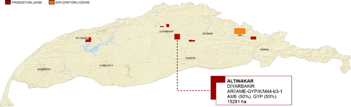
In 2011, 14 API oil was discovered in the Cretaceous aged Mardin Group carbonates in the Altınakar-1 well and a total of 473 barrels of oil was produced. The well was deepened to the Bedinan sandstone reservoir (B4) in 2012 and 41 API oil was discovered. The Altınakar field is located on the same structural trend as the other Bedinan oil fields in the eastern areas, namely Şükürlü, Kılavuztepe, Arpatepe and Çalıktepe fields.
In 2020, three exploration wells, Altınakar-2 (TD: 2291m), Altınakar-3 (TD: 2312m) and Altınakar-4 (TD: 2297m), were drilled targeting B4 sandstones (Sand-1 and Sand-2). The lower Sand-2 level in the Altınakar-2 and Altınakar-3 wells was put into production with a flow rate of 600 barrels/day and natural flow. Since formation water came from the Sand-2 level in the Altınakar-4 well, the Sand-1 level was put into production with a flow rate of 10 barrels/day. As of the end of 2022, the average production amount of these three wells was 235 barrels/day.
Altınakar-5 well (2022) was drilled 2km east of Altınakar-2 well, targeting Bedinan sandstones. The well was terminated and temporarily abandoned at a final depth of 2302 m without any oil sign.
In order to detail the structural interpretation of the main faults in the license area, 114 km of new 2D seismic data were collected in 2022. As a result of the interpretation of this data, many prospective closure areas were described in the Paleozoic fault blocks. In order to test the oil accumulation in a different fault block, it was decided among the partners to open at least one exploration well targeting Bedinan sandstone in 2023.
Başaklı-1 (2014) is located 7 km north of the Altınakar field. Mardin Group carbonates were targeted as the primary reservoir in this well. A total of 39,000 barrels of 21 API oil were produced from this reservoir level until 2019. The well was later deepened to the Bedinan sandstones, but no significant oil evidence was observed.
The land structure is 950 m west of the Paleozoic oil exploration well Basalan Bedinan-1, which has a daily artesian flow production of 150-200 barrels.
Karalar-1 was spud in November 2023. Karalar-1 and the subsequent directional drilling of Karalar-1S wells were abandoned due to technical problems. A new well with a larger casing design is planned to be drilled. Karalar-1K was spud on February 27, 2024. The basalan Bedinan-1 well is planned to test the potential of Ordovician Bedinan Formation sandstones in an up-bottom hydrocarbon structure.
The West Altınakar-1 well was spudded in January 2024 and its final depth targeting Bedinan Formation sandstone reservoirs is planned as 2345 m. West Altınakar-1 is located 2.5 km west of the Altınakar oil field and 5 km east of the Şükürlü oil field.
Dadaş "hot shales" are the main source rocks of the Paleozoic petroleum system. The Altınakar-Başaklı license falls within the Dadaş source rock distribution area and is therefore considered to be an important advantage for planning future exploration activities.
Honeycomb
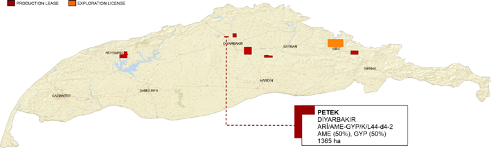
The honeycomb field is located 12 km west of the Karakilise field. The honeycomb structure is 2 km2 in size, closed on three sides, along a normal fault extending east-west. A total of four wells have been opened on the structure in the last ten years.
The Petek-1 well was first drilled in 2013 targeting Bedinan sandstones and reached a final depth of 2917m. Condensate and gas signs were observed during the excavation of the Bedinan and Dadaş Formations. The Petek-1 well was completed at the Mardin level after the tests conducted at these reservoir levels failed. During the tests, 35.9 API oil flowed with a flow rate of 90 barrels/day. The well was put into production in February 2014 at a natural flow rate of 15 barrels/day.
Petek-2 well was drilled in August 2017 with a final depth of 2274m, targeting the same reservoir, and was put into production in October 2017 with a flow rate of 100 barrels/day.
The Petek-3 production well was drilled in March 2019 and completed in April at a depth of 2264m in the Mardin carbonates. At this level, a flow rate of 14-15 barrels/hour was measured in DST-1, which was made between 2234-2264m, and a total of 47 barrels of oil were recovered.
Petek-4 was dug to a depth of 2267m on August 4, 2022. The well was put into production in November 2022 with a flow rate of 200 barrels / day at the Mardin group carbonates level.
Production in Petek-3 and Petek-4 wells continues with pumps.
In this region, the unconventional potentials of Bedinan and Dadaş Formations should also be taken into consideration. The Paleozoic exploration well Çiksor-3 (2011), located next to the license, was drilled in the lower flank of the Petek structure (1.5 km northwest of Petek-1) and oil and gas were tested in the Bedinan-Dadaş formations. Considering the hydrocarbon traces encountered in Petek-1, it is thought that the Paleozoic targets trapped in the Petek fault have significant hydrocarbon potentials.
Arpatepe
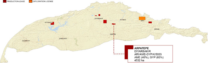
Until late 2007, the prevailing view about the hydrocarbon potential of the Ordovician Bedinan sandstones was that they had a limited distribution area around small oil fields along the southern foreland areas. The discovery of oil in the Arpatepe field by partners including AME in 2008 changed this idea. This discovery was the first Paleozoic oil discovery in our country. In the following years, many operators actively explored Paleozoic fields and discovered many Bedinan fields of various sizes. The Diyarbakır basin is still an area that has not been sufficiently explored and has the largest Paleozoic hydrocarbon potential.
Arpatepe-1 tested 41 API oil in the Bedinan quartz-rich sandstone member (B4) in a reservoir interval up to 35 m thick and the well was put into production with a natural flow of 350 bbl/day.
For better development of the field, 252 km2 3D seismic was collected in 2009. The quality of the seismic data collected in the region is good enough to describe even the fine structures at the Paleozoic reservoir level.
During the exploration and field development phases, seven more wells were drilled along the Arpatepe fault closure. Production continues with four wells.
The Northern Arpatepe-1 well was drilled in June 2022, 2.2 km north of the Arpatepe field, in a separate basement fault closure, to test the presence of a commercial oil inclusion in the Bedinan sandstones. The well could not reach the final depth due to technical reasons and was temporarily abandoned in the Dadaş formation.
TransAtlantic Petroleum's 50% stake in the Arpatepe production field has been purchased by AME and GYP. The new share structure is currently AME 40% and GYP 60%. Government approval has been received for this change and announced in the Official Gazette on September 25, 2023. The new license name is listed as ARİ/AME-GYP/K/5003.
Workover operations are carried out regularly in production wells. In March 2024, Arpatepe-1 and Arpatepe-6 wells were put back into production using production packers.
Reshan
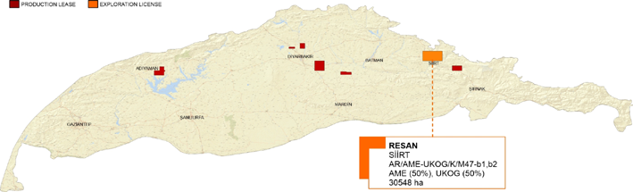
The Reşan license is an important exploration license not only with the discovery of the Oymantepe field in the Doğu Sadak license by AME in 2014, but also in many other respects; the Cretaceous hydrocarbon system with proven potential, the existence of thrust structures in the Tilan-Başur-Reşan axis that have not yet been tested, the Mardin-targeted structures in the tectonically calmer eastern part of the license, and the seismic amplitude levels in the Eocene-Oligocene formations.
The main target reservoirs are the Upper Cretaceous Beloka and Mardin Group carbonates located in the Reşan-Başur anticline. There are many wells in the license area that have tested oil on this trend; Başur-1 (1965) produced 325 barrels of oil during testing, Reşan-5 (1957) tested 20 liters of oil during DST, and oil shows were seen during drilling of Reşan-2 and Reşan-3 (1955). Tilan-1 (1966) is 3.8 km east of Kurtalan-1 (1961) well, which produced a total of 219,000 barrels of 33 API oil from the Garzan formation between 1961 and 1971. The Tilan structure has been remapped with new 2D seismic data.
In June 2021, the Başur-3 exploration well was planned to be drilled directionally next to the Başur-1 well, where oil production had previously been made, but it was abandoned in June 2021 due to technical reasons within the Lower Germav formation before reaching the planned target levels.
During the 2D seismic data acquisition program in 2022, light oil (41-47 API) leaks were observed in dynamite wells. In addition, oil traces were encountered in the limestones at the base of the Germik Formation in the Kezer-1 well drilled in the nearby region in 2019. In the same well, emulsion came to the surface while lowering a 9 5/8” casing onto the Hoya Formation. In addition, a shallow target exploration concept was developed upon the detection of high amplitude seismic anomalies on an old 2D seismic line passing through this location. Pinarova-1 well was drilled to a total depth of 600 m in April 2023 to test the shallow amplitude target concept. After extensive well completion operations, the well was abandoned in February 2024 due to the failure to recover any hydrocarbons in commercial quantities.
In order to detail the structural features of the Reşan-Başur area, all surface geological data were combined with interpretations of seismic and well data to determine suitable areas for drilling.
Additional gravity and 2D seismic data are needed to better define the “Mardin” targets located on the Siirt side of the license.
Black Church
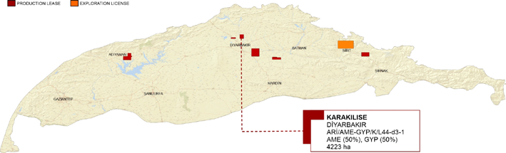
Karakilise production license is located 30 km north of Diyarbakır. Karakilise-1 exploration well was started to be drilled in June 2003 and was completed with the discovery of 31 API oil in Mardin Group carbonates (Karababa-C) at a depth of 2472 m. The well was put into production in September 2003 with a flow rate of 380 bbl/day. Karakilise field is on the same trend as other fields, Petek and Bostanpınar, which have similar structure and production from reservoir level.
Mardin Group carbonates are the main reservoir unit in the SE Anatolian Basin. In general, dolomitic wackestones of the Karababa-C member of the Karababa Formation and dolomites of the Derdere Formation are the main reservoir levels. Dolomitic reservoirs of the Mardin Group can exceed a matrix porosity of 20% and have a permeability of 10 md. Natural open fractures also increase production, but the degree and orientation of fractures are closely related to regional stress regimes. Sayındere and Kastel Formations, which overlie the Mardin carbonates, are good cover units.
After the Karakilise-1 (2003) oil discovery, Karakilise-2 was drilled in November 2004 targeting the same reservoir and was completed as a dry well at a depth of 2525 m.
In September 2006, the Karakilise-1 well was deepened into the Bedinan sandstones (B4) to prove commercial oil accumulation, but the well had to be completed in the Derdere Formation.
Hakan Yılmaz-1 well was drilled to a depth of 2,502 meters on a separate Mardin closure, 1.7 km south of Karakilise-1R well. Oily mud was recovered during both DSTs (#2 and #3) in the well, but the well could not be completed due to technical problems and was abandoned in July 2008.
A 20km 2D seismic program is planned on the Karakilise and Hakan Yılmaz inclusions, with the aim of drilling a new well in 2024 and remapping the Bedinan-Mardin reservoirs.
Karakilise oil field is located in the same trend as other important oil fields, 9km east of Bostanpinar (2011) and 5km east of West Bostanpinar (2019). Both are producing oil at 30.2 API and 21.3 API gravity, respectively, from the Mardin Group Derdere Formation.
Zeynel-Nimrod
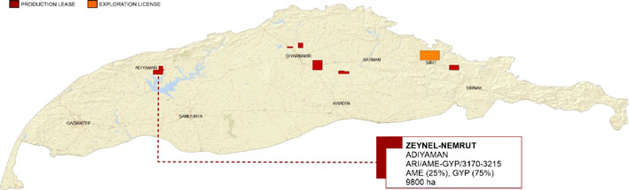
The Zeynel-Nemrut license covers an area of 9800 hectares within the borders of Adıyaman province in the west of the SE Anatolian Basin. It is surrounded by important fields such as Çemberlitaş and Adıyaman oil fields in the northwest, Karakuş and Güney Karakuş fields in the northeast, and Kahta oil field in the southeast.
The Zeynel structure is located in the transition zone between the foreland and the slope belt. It is a thrust elevation bounded by main faults from the south and east, extending in the southeast-northwest direction. The presence of the underground anticline was defined with 13 different 2D seismic data collected using different data acquisition parameters.
The Zeynel-Nemrut oil field was discovered by AME in December 1989 with the Zeynel-1 well. The well was completed at a depth of 1500 m within the Karababa-C member. Up to now, 23 wells have been drilled in the Zeynel field, 5 in the Nemrut field and 4 in the Hasancık field. The Zeynel wells have an average depth of 1500 m. The majority of the production wells have been completed as open-pits.
The Nemrut structure is located in the southeastern extension of the larger Zeynel structure. It was discovered in November 2006 with the Nemrut-2 well.
In the region, Upper Cretaceous Mardin Group carbonates, Karaboğaz and Sayındere formations are the main reservoir units. The underlying Turonian-Cenomanian Karababa and Derdere formations are secondary targets.
Germav Formation shales are the main cover unit. Karaboğaz and Sayındere formations, which are uncracked to the Mardin Group carbonates, are also seen as local cover rocks.
Pelagic facies of the Derdere Formation and dark muddy carbonates of the Karaboğaz Formation have good source rock properties.
According to recent seismic interpretation studies, many untested prospective areas have been defined within the Zeynel license, especially in the west of the license.
East Sadak (Oymantepe)
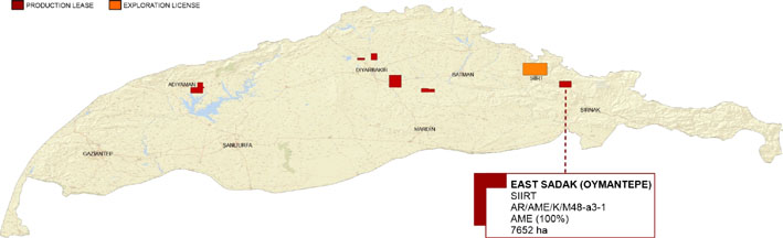
The Eastern Sadak license is located southeast of Siirt, covering an area of 7,652 hectares. It is on the same structural trend as the most productive oil fields in the SE Anatolian Basin.
There are two surface anticlines in the license area. The lightest oil discovery in our country to date was made in the Doğu Sadak-1 well, which was opened in 2014 on the surface anticline in the west, with an API gravity of 43. After this discovery, the field is called “Oymantepe”. A total of 14 exploration and development wells were opened in the Oymantepe field, 6 of which were directional and one of which was drilled twice.
The main reservoir units are the Upper Cretaceous Beloka Formation and the Mardin Group carbonates. Jurassic Cudi Group carbonates are considered as a secondary reservoir level, but none of the Doğu Sadak wells have been drilled to test this reservoir yet. On the other hand, the Cudi Group reservoirs can be tested with a well with an average final depth of 3800 m.
The Beloka Formation consists of fractured limestones and dolomites with low matrix porosity (4-6%). Mardin Group carbonates have higher matrix porosity of up to 15%. Development and production wells in the field, starting with Doğu Sadak-6 (2018), are being completed as open wells in order to minimize contamination at reservoir levels.
Although the Garzan Formation is one of the main producing reservoirs in the region, it is not a formation that produces in the Oymantepe field. On the other hand, studies are ongoing to better understand its potential.
Despite the use of heavy drilling mud during drilling of the Paleocene Upper Sinan Formation, significant oil signs were observed in many wells. AME is working on shallow well designs to test the hydrocarbon potential of this reservoir.
In 2022, DS-9/DS-9R and DS-15/DS-15S wells were drilled. Due to difficulties experienced during drilling of the DS-15S (SD: 1973m) well, the planned depth could not be reached and the well was abandoned. DS-9R (SD: 2890m) was tested as an oil well and was put into production with a daily oil production rate of 40 barrels.
A total of three wells were drilled in 2023: DS-16, DS-5S and DS-17. Well DS-16 was abandoned due to drilling difficulties at shallow depths. Directional well drilling of DS-5S was started in July 2023 and completed at a depth of 2645 m in the Mardin Group carbonates. Although high gas readings were recorded during drilling of the Beloka Formation, this interval was plugged and abandoned and the Garzan Formation was perforated above. Drilling of DS-17 was started in October 2023 and completed at a depth of 2573 m in the Beloka Formation. As of March 2024, well completion operations are ongoing in wells DS-05S and DS-17.
Bartin
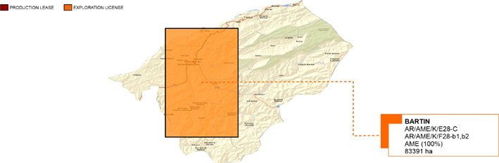
Bartın land licenses cover a total area of 83391 hectares in the Western Black Sea region. The main reservoir is the gas-bearing sandstone intervals with AVO sensitivity in a turbiditic sequence of the Eocene Kusuri Formation. Its thickness varies between 500-4000m in the region. The clayey limestone intervals of the Akveren Formation are considered as secondary targets. Its thickness varies between 100-800m in the region. There are two hydrocarbon systems operating: These are the Carboniferous/Early Cretaceous and Tertiary systems.
The best analogy is the offshore gas fields in the nearby Southern Akçakoca Sub-Basin (GAAB). Within the framework of similarities with the GAAB gas fields, various prospective areas have been defined using the existing 2D seismic data within the license area.
Although significant gas signs were observed in almost all wells drilled in and around the Bartın license between 1987 and 2009, no well resulted in a commercial discovery.
In 2020, the Sakarya gas field was discovered with the Tuna-1 well 100 km north of GAAB and since then this new gas field has been rapidly developed with additional wells. The Sakarya gas field is the largest gas discovery in the country with a gas reserve of 710 TCM (25.1 TCF). This discovery proves that there can be significant natural gas production from source rocks and similar gas deposits in the region are likely to be productive both offshore and onshore extensions.
AME continues its work to unlock the potential of the Bartın license. It is looking for partners in the Bartın exploration licenses within the scope of the work program planned to include 2D seismic data and an exploration well. The scope of the work program will be determined by bilateral meetings.
AME is seeking a new partner to undertake the drilling costs and new seismic/non-seismic surveys of an exploration well to a total depth of 2500m to test gas potential in both the Kusuri and Akveren formations in exchange for a 50% stake in all exploration licences in Bartın. The extent of new seismic data collection is subject to negotiation.
The company that will participate in the license as a partner will cover all the costs of the work program, provided that it will not bear any retroactive costs, and will then be responsible for its share of the costs in proportion to its share.
LEADERSHIP
Yilmaz Oz Honorary Chairman of the Board of Directors
Cem Sayer Chairman of the Board of Directors
Stuart Perth Financial Advisor to the Board of Directors
Edouard Brain Finance Director
Erdem Kaya General manager
Muharrem Ince Director of Operations
Cagatay Beydogan Deputy General Manager for Administration
Bora Sayer Business Development Specialist
Emrah Can Search Manager
Sema Ersay Finance Manager
Cem Ozsoy Financial Controller
George C. Bruce Vice Chairman of the Board of Directors
CONTACT
Aladdin Middle East Ltd.
Karum Business Center
Iran Street No:21/394 Kavaklıdere
Ankara, Turkey
+90 (312) 427 90 20
info@ame.com.tr
KeyFacts Energy: Aladdin Middle East Turkey country profile l KeyFacts Energy: Company Profile