The latest release of Getech’s industry leading Multi-Sat 2020 data ushers in a new era of resolution and accuracy for altimetry derived gravity.
Users now have a dataset that provides previously unattainable confidence in mapping the sub-surface geology, over all of the world’s offshore continental margins.
The Getech team has been able to integrate data from several new missions and create advances in the processing workflow so that the new data provides a number of valuable benefits:
- A realistic high resolution 1km grid: everywhere.
- A constrained, tighter network of input data for greater accuracy and reliability.
- Data free from track artefacts and directional biases.
- Greater coverage close to coasts, which is free from onshore interference and makes better use of different sensor modes.
Gravity 2.0
Gravity data is an extremely valuable tool for mapping sub-surface geological structure and composition, over large areas.
In offshore areas, high-resolution data acquired (for example, from onboard ships alongside seismic data) are typically integrated with regional data, perhaps from earlier generations of satellite altimetry.
This helps the interpreter expand their analysis over extended areas but can make coherent mapping problematic, because of these changes in resolution.
Quantitative analysis is particularly hampered by changes in data character not necessarily related to sub-surface relief and composition.
Getech’s latest Multi-Sat 2020 data significantly closes this resolution gap, and hence provides a higher confidence in which to assess your exploration areas in consistent detail.
Whilst still providing a fantastic framework into which to integrate your proprietary surveys, the self-consistent 1km resolution gravity grid now gives comparable detail to regional marine gravity!
These new data are already being actively used in projects to map structural prospects and intra-sedimentary features at a previously unachievable scale.
The Six-Satellite Solution
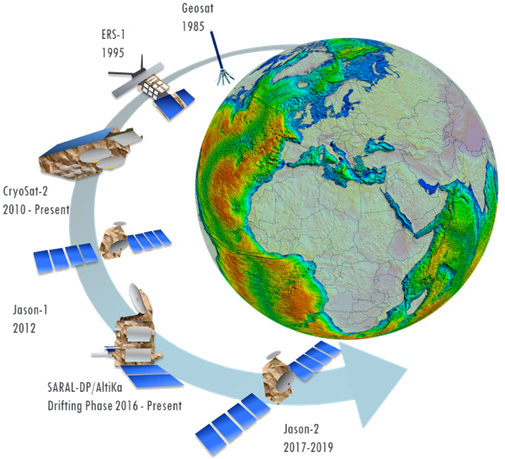
Getech has long been at the forefront of the generation of gravity from satellite altimetry data and prior to embarking on this latest 18-month Multi-Sat 2020 project we shared with you some of the background in this blog:
Key to the advances of this product is the successful integration of 12 cycles of altimeter data, including 5 cycles from new missions of AltiKa DM and Jason-2 alongside previously processed cycles from CryoSat-2, Jason-1, ERS-1 and Geosat.
The 3 new cycles of the AltiKa DM provide close, irregular spaced tracks which when combined with the 2 cycles of Jason-2 data (the second of which is interleaved) have yielded a significant uplift in the satellite tracks spacing.
The animation shows how the gravity resolution has improved from our 2004 “2-satellite” solution, through our 2016 “4-satellite” solution to this 2020 “6-satellite” solution.
Learn More
The availability of a clean, coherent 1km gravity grid for all offshore continental margins of the World gives the natural resource explorer and geological mapper a significant head-start in their exploration campaign.
The greater confidence to extend interpretations away from marine surveys, potentially at equivalent resolution means that detailed features can be confidently mapped in a timely and cost-effective manner than has been previously achievable.
To learn more about how our leading gravity data can help your projects, please contact our Gravity and Magnetic solutions team at gravmag@getech.com
KeyFacts Energy Industry Directory: GETECH