
By Tamsin Lawrence, Senior Nannopalaeontologist / Deputy Department Manager at PetroStrat
Geology Walks In Wales – Conwy to The Great Orme Coastal Walk
The walk starts at the western the beautiful walled town of Conwy, home of PetroStrat Head office.
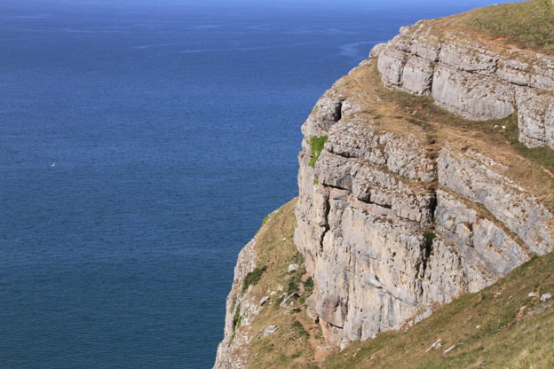
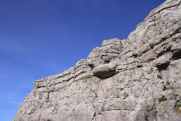
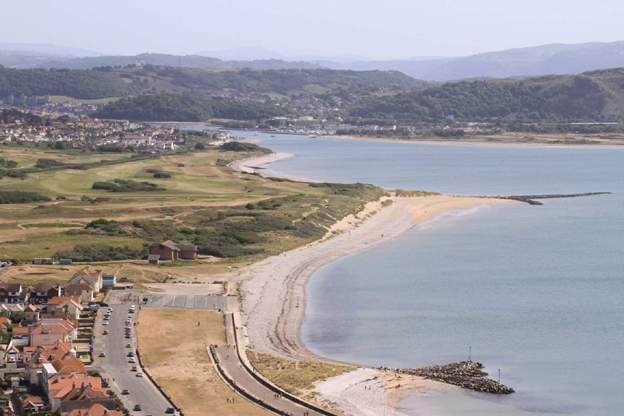
The Great Orme is a peninsular formed of limestone and dolomite, deposited during the Early Carboniferous, between 339 and 326 million years ago. It is one of the most continuous outcrops of Carboniferous sequences in the UK. Take some time to explore the criss-cross of paths across the Orme, taking in the views of Conwy, Snowdonia, exploring limestone pavements and the Bronze age Great Orme copper mine, one of the largest prehistoric mines in Europe. Don’t forget to look out for the Kashmir goats that cling to the cliff edges!
1. Start by walking a circuit of the exceptionally well-preserved Town Walls, built by Edwards I of England between 1283 and 1289, part of a World Heritage site. Look out for the Conwy Rhyolite Formation, which is made up of rhyolite lavas formed during the Ordovician period (between 450 and 460 million years ago) of which sections of the Town Walls are made, along with sandstone and limestone.
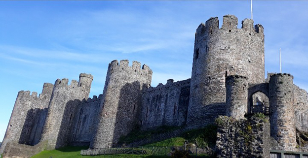
2. Finish your Conwy tour by the impressive Conwy Castle, and head across the Conwy suspension bridge, designed by Thomas Telford and completed in 1826. Be careful as you cross the road at the end of the bridge, onto the main road bridge and causeway, and pick up the Wales Coast Path heading roughly North, following the railway line towards the small town of Deganwy. There are spectacular views back across the river to Conwy Castle and the Snowdonia mountains beyond.
3. Reaching Deganwy, you will see the Conwy Marina across the Conwy River, site of a temporary harbour developed in WWII. Behind you the twin hills known as the Vardre, which is home to the remains of Deganwy Castle, are the result of volcanic activity. The castle was destroyed by Llywelyn in 1263 to prevent its use by the English; building materials were robbed for use in Conwy Castle across the estuary.
4. Continue along the coast path heading for the Great Orme. Continue through sand dunes and along the impressive West Shore Beach, a great place for a paddle on a warm day, until you reach the base of the Great Orme which dominates the skyline ahead.
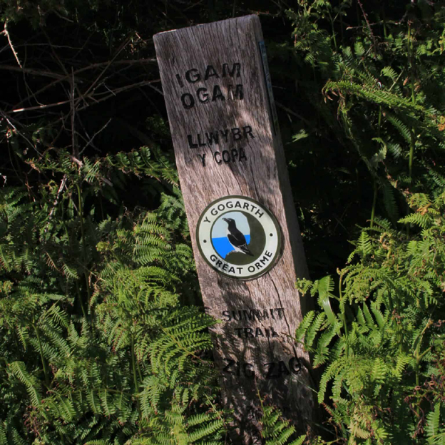
5. At the farthest end of the beach, cross the road to a gate and onto a footpath that take you up onto the flank of the Great Orme. There are many options from here to take you to the summit, but you can follow the signposts for the Great Orme Summit which takes you steeply up the left about 500m beyond the gate.
6. From the Summit station, follow the Tramway (built in 1902) down the road for spectacular views of the Victorian seaside Town on Llandudno, with its Victorian Promenade, Pleasure Pier and views to the Little Orme, where the walk ends. The town is a popular tourist destination with plenty of choices for cafes, pubs and restaurants to finish up the day.
Geology Walks In Wales – Llanberis and Dinorwig Quarry Walk
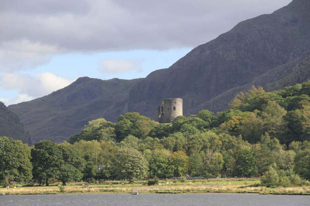
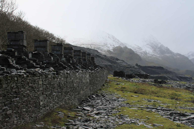
The walk starts in the mining town of Llanberis, at the foot of Mount Snowdon, the highest peak in Wales. Park in one of the many car parks along the bank of Llyn Padarn, with fantastic views of the peaks of Snowdonia all around. This walk explores some of the North Wales slate quarries, taking in spectacular mountain views. The slates, of purple and green colour, and were formed as deep-water mudstones, which were uplifted, folded, and metamorphosed to form slate about 400 million years ago, are of Cambrian age.
1. Follow the road rough Southeast towards Dolbadarn castle, which towers above the end of the lake, overlooking the Padarn Country Park. Take a short de-tour up the hill through the forest to visit the castle (free). The castle is thought to be constructed by Llywelyn the Great in the late 12th or early 13th Century.
2. Drop back down to the road and continue until a bridge which crosses the river that links Llyn Padarn and the Llyn Peris Reservoir. At the road junction, near the roundabout, look for the entrance that heads into a steep slate walled path that will take you up into the quarry. Note whilst short, this path is steep and uneven and be careful of the sharp slate.
- You can also take a de-tour to the left to explore the National Slate Museum, the spectacular Vivian Quarry (now a diving site) and the Llanberis Lake Railway.
3. Returning to the main route, follow this path until you reach an incline, passing various ruined building, including the famous Anglesey Barracks, built in the 1870s. They were condemned unfit for human inhabitation in 1948. Be careful to stick to the paths so as not to trespass on private land or enter any dangerous areas as you explore. When an incline in reached, ascend this to meet the main path through the quarries.
- The Dinorwig quarry came into operation from the 1770s, at one point employing over 3000 men. It was closed in 1969.
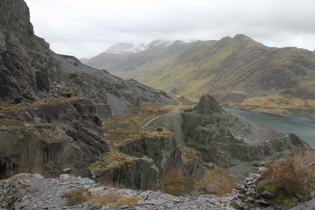
4. A great viewpoint to the left is worth a very short de-tour, before continuing along the main path to the right. Continue following this path as it zig zags down the mountain towards the shores of Llyn Peris, before meeting the main road.
5. Turn right here and follow the shores of Llyn Peris back to Llanberis. There are spectacular views back to the quarries from across the lake and the Dinorwig Power Station, a hydroelectric scheme built into the side of the mountain.
Geology Walks In Wales – Anglesey geology, Llanddwyn Island and Newborough Beach Walk
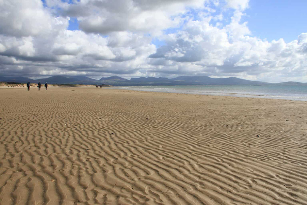
The walk to Llanddwyn Island starts from the Forestry Commission car park at Newborough (toll road) on the beautiful Isle of Anglesey. There are facilities such as toilets, BBQs and picnic areas at the carpark. The car park is set within extensive pine forests which meet the sand dunes that back the spectacular beach. Check the tide times before travel, as the tidal island can become completely cut off during very high tides!
Before heading for Newborough, make time to stop off to see the famous Anglesey blueschists – some of the oldest known in the world. Marquess of Anglesey column sit the woods around some of the best exposures. The blueschists, formed around 570 million years ago were formed when basaltic pillow lavas from the ocean floor of the descending plate were subducted and metamorphosed.
The Island is a National Nature reserve, so collecting is prohibited.
1. From the car park, head through the sand dunes and down onto Newborough Beach. The clear, shallow waters are perfect for a hot summers bay, and huge beach at low tides means there is plenty of room to spread out. There are spectacular views across the water to the Llyn Peninsular and the Snowdonia Mountains.
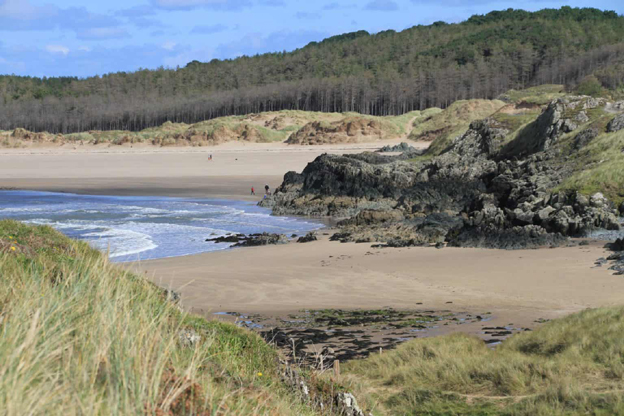
2. Turn right along the beach and head in the direction of the Island, about a mile or so along the beach, with the forest and sand dunes to your right.
3. As you approach the Island, you will see first a world-famous exposure of pillow lava. Formed from basalt, which was erupted from the ocean floor; the cool water rapidly cooling the molten rock into pillow like structures. These pillow lavas are part of the Precambrian Gwna Group.
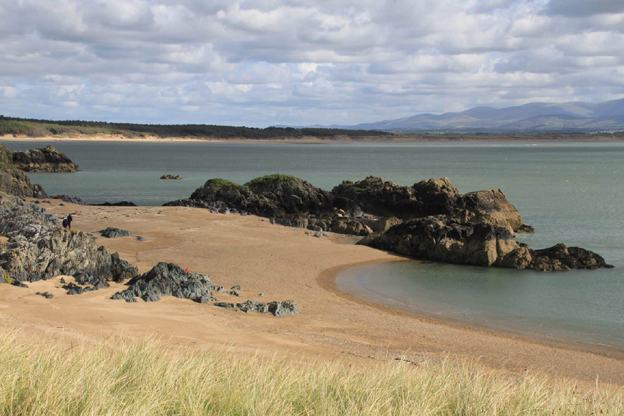
4. Continue across the sandbank and onto the Island. There is a good network of paths criss-crossing this small island to explore, atop the low, rocky cliffs, across golden sandy beaches, and through waving sand dunes.
5. Cross to the step where you will see the remnants of explosive lava, purple and green in colour, with the remains of very small pillows lavas. Climb the steps and take the right-hand path across the cliffs where you can see alternating bands of green and red rocks. The green colour of these metamorphosed rocks, the red from iron-rich silica deposits.
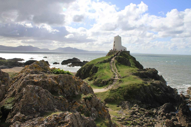
6. Continue across this path until you view the spectacularly situated light house and continue down toward the end tip of the island before heading left to the small bay of Porth Twr Back (below the tower and with spectacular views of Snowdonia across the water). The mix of colours and textures here was christened “mélange” by the first geologist to describe them, Edward Greenly.
Return to the main path, past the Pilots Cottages, and continue along the main path through the centre of the Island, taking a moment to stop at the remains of the sixteenth centre church before heading back across the causeway, onto the beach and back to the car park.
Bonus Tip – Its also worth stopping at Llanfairpwllgwyngyllgogerychwyrndrobwllllantysiliogogogoch the town with the longest place name in the UK!
KeyFacts Energy Industry Directory: PetroStrat