GeoStreamer X data reliability and accuracy have been reinforced in a First Break paper out in September. The paper shows how our innovative solution, using multi-azimuth broadband seismic with wide-tow triple-source shooting, has overcome the main exploration challenges in the prolific southern Viking Graben.
The multi-azimuth multisensor data have enabled existing fields and known discoveries in the area to be accurately mapped and new leads and opportunities suitable for near-field exploration have been highlighted.
- Read the full article ‘Multi-azimuth multisensor quantitative interpretation: a South Viking graben case study, Norway’
- Find out more in our case study 'GeoStreamer X for accurate and efficient lead characterization'
With improved understanding and characterization of the various reservoir intervals, evidence of additional nearby hydrocarbon potential has been revealed.
The integrated approach of acquisition, imaging and reservoir characterization has delivered encouraging results in a very cost-efficient and effective manner.
Several additional wells have been drilled following the Lille Prinsen discovery, to examine the potential in the deeper stratigraphic intervals such as the Jurassic sandstone and the Permian. In the image below, based on our elastic-attributes extraction on the pre-Cretaceous interval, clear indications of hydrocarbons are visible at the Upper Jurassic and Zechstein levels. These anomalies are of reasonable size and could constitute interesting near-field exploration targets.
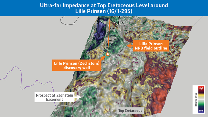
Ultra-far relative impedance map extraction is highly correlated to Vp/Vs at the top Cretaceous over a 16ms window. Blue anomalies match well with the Norwegian Petroleum Directorate (NPD) outline for the Lille Prinsen discovery at this level. A visible anomaly further north-west was tested successfully by a recent appraisal well. Additional opportunities exist to the south of Lille Prinsen, as well as down-flank.
KeyFacts Energy Industry Directory: PGS