Before the geophysical survey is undertaken, the offshore wind farm area is truly an alien world beneath the waves. Are there hills, mountains, ridges, deep holes, reefs, rocks, or smooth beach sand? Is the bottom hard as a rock, or soft as mud? Is it an ideal place for endangered or economically sensitive species live?
The advanced technologies provided by Acteon are able to define these physical traits and details to make this alien world accessible and knowable to planning engineers.
GEOPHYSICAL SURVEYS ILLUMINATE A HIDDEN WORLD
Planning to construct a commercial scale wind farm requires knowledge of the shape of the earth (morphology), the geologic makeup of the earth, and the condition of the seafloor. Each of these items is critical to plan the type of foundation for the turbines, the magnitude of ground disturbance and geoengineering that will be required to set that foundation, the presence of hazards to the construction/maintenance activities and the specific layout of the field. This process is greatly complicated by the fact that these offshore wind farms are to be built on ground that no one (or very, very few) have seen. Geophysical surveys allow us to reveal the world that is hidden beneath the waves and make it readily accessible to the planning team.
Tools include wide coverage high-resolution multi-beam sonars, dual magnetometers, high-resolution towed side-scan sonars, high-resolution/shallow-penetration subbottom profilers, medium-penetration single/multi-channel seismic systems, precise positioning GNSS and motion units, and ultra-short baseline underwater positioning sensors among many others. Surveys range from the beach out tens of kilometers offshore to about 75m depths.
GEOPHYSICAL SURVEYS PROVIDE ACCURATE AND PRECISE DATA
Geophysical surveys not only provide a general overview but also details for planning cable routes, pile driving, mooring conditions, anchor plans and more. The ability to map and define the ocean floor to a sub-meter level of detail provides the planning engineer with data that approaches the accessibility of worksite that is on land, a worksite that can be conceptualized as a whole and provides planners with the knowledge that, though they can’t drive to this work-site, there is enough information available to proceed confidently and safely.
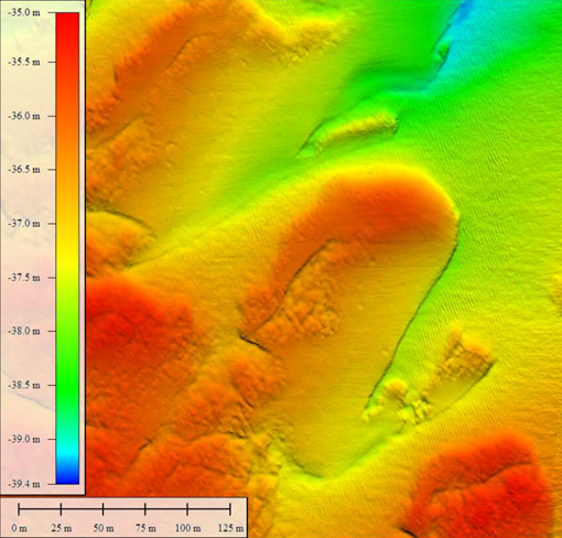
Geophysical survey
The ability to map and define the seafloor provides planners with the knowledge that, though they can’t drive to this work-site, there is enough information available to proceed confidently and safely.
GEOPHYSICAL SURVEYS PROVIDE A CONTINUOUS MODEL IN SUPPORT OF GEOLOGIC DATA
Geophysical surveys provide a continuous model in support of geologic data taken by geotechnical information. A geotechnical core provides a wealth of information about the geology of the project ground. It is, however, akin to examining the sub-surface through a keyhole. It is a true-life sample; an accurate reflection of what stratigraphy is below the seafloor at that point. By combining the geophysical modeling with the geologic truthing of the core results, a more continuous ground model can be developed. Plans often change for a variety of reasons and the location of a turbine is a very expensive plan to change. The existence of geophysical survey data, properly referenced to the geotechnical investigations, allows for area wide flexibility in examining the variations in the subsurface. Are these sands related to a filled channel? Does this clay layer extend everywhere in the Wind Energy Area, if so, does it vary with depth, slope, or thickness? Are these carbonate samples part of a large reef complex, or just an isolated event? The geophysical data collected in our surveys expands upon geotechnical results and accurately describes what is occurring between borings, possibly eliminating the need for further geotechnical investigation, or, identifying an area where further geotechnical exploration would be very valuable to the project.
KeyFacts Energy Industry Directory: Acteon